Search Results for author:
Found 13 papers, 7 papers with code
Satellite Imagery and AI: A New Era in Ocean Conservation, from Research to Deployment and Impact
Illegal, unreported, and unregulated (IUU) fishing poses a global threat to ocean habitats.
Zooming Out on Zooming In: Advancing Super-Resolution for Remote Sensing
Super-Resolution for remote sensing has the potential for huge impact on planet monitoring by producing accurate and realistic high resolution imagery on a frequent basis and a global scale.

SatlasPretrain: A Large-Scale Dataset for Remote Sensing Image Understanding
Remote sensing images are useful for a wide variety of planet monitoring applications, from tracking deforestation to tackling illegal fishing.


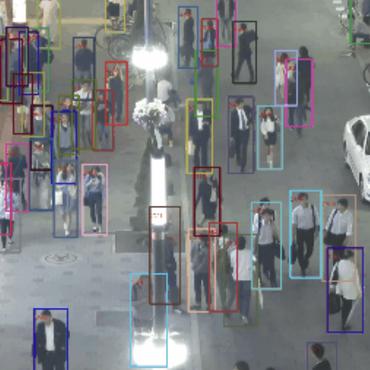
Self-Supervised Multi-Object Tracking with Cross-Input Consistency
In this paper, we propose a self-supervised learning procedure for training a robust multi-object tracking (MOT) model given only unlabeled video.

Updating Street Maps using Changes Detected in Satellite Imagery
To address this challenge, much work has studied automatically processing geospatial data sources such as GPS trajectories and satellite images to reduce the cost of maintaining digital maps.
Beyond Road Extraction: A Dataset for Map Update using Aerial Images
The increasing availability of satellite and aerial imagery has sparked substantial interest in automatically updating street maps by processing aerial images.
Synthesizing Video Trajectory Queries
A key challenge is that queries are difficult for end users to develop: queries must reason about complex spatial and temporal patterns in object trajectories in order to select trajectories of interest, and predicates often include real-valued parameters (e. g., whether two cars are within a certain distance) that can be tedious to manually tune.
TagMe: GPS-Assisted Automatic Object Annotation in Videos
We show TagMe can produce high-quality object annotations in a fully-automatic and low-cost way.
Sat2Graph: Road Graph Extraction through Graph-Tensor Encoding
Inferring road graphs from satellite imagery is a challenging computer vision task.
RoadTagger: Robust Road Attribute Inference with Graph Neural Networks
The usage of graph neural networks allows information propagation on the road network graph and eliminates the receptive field limitation of image classifiers.
Inferring and Improving Street Maps with Data-Driven Automation
Through an evaluation on a large-scale dataset including satellite imagery, GPS trajectories, and ground-truth map data in forty cities, we show that Mapster makes automation practical for map editing, and enables the curation of map datasets that are more complete and up-to-date at less cost.
Machine-Assisted Map Editing
Systems to automatically infer road network graphs from aerial imagery and GPS trajectories have been proposed to improve coverage of road maps.
RoadTracer: Automatic Extraction of Road Networks from Aerial Images
Mapping road networks is currently both expensive and labor-intensive.
